


Meadow Lake
We have hiked and mountain biked around miles of trails in the Lake Tahoe area, but I can already see that after only a few weeks of having our canoe that we are going to be discovering all kinds of new terrain.

Inga & Cindy
Steve and our good friend Cindy loaded up the canoe and took off for Independence Lake, located in forested recreation lands northwest of Lake Tahoe. We drove to Truckee, headed north on Highway 80 for a short distance, and then took the Highway 89 exit north, traveling a little more than 13 miles. Passing green meadows and winding mountain streams ringed with granite peaks the three of us remarked that we had no idea such scenic terrain lay in this relatively un-traveled area. We kept an eye out for Forest Route 07, which, according to the map, would take us to Independence Lake. Signage was lacking for the forest service road numbers, but was plentiful pointing the way to Independence Lake.
When we arrived at Independence Lake we were greeted with a large sign stating that it was closed for the season, by order of the owner, Sierra Pacific Industries, a lumber operation and California’s largest landowner. Disappointed, we pulled out the map to find that there were many other lakes dotting the area. Back on Forest Service Road 07 we noted signs providing direction to some of the nearby lakes, including Jackson Meadow Reservoir. Relieved, we headed toward the reservoir, spying several lakes off in the distance. For no good reason we spontaneously changed direction and decided instead to go to Meadow Lake, turning left on FS 86. Bumping and bouncing along the dirt road we hoped our Jeep Grand Cherokee would live up to the Madison Avenue hype in advertisements showing off-road jeeps performing backcountry feats. Leaving the well graded forest service roads we transitioned to rougher roads on Pacific Gas & Electric (PG&E) company roads. Sierra Pacific and PG&E are both huge landowners in California, much of the land in wilderness areas, and many customers and others are unaware that much of this land is open to the public either for no or low fees.

Meadow Lake
After a total of 10 miles on dirt roads we jostled up to Meadow Lake in a cloud of dust, emerging from the narrow track onto a lovely alpine lake thick with trees ringing most of the shoreline, thinning into a gently sloping meadow on the far side. Parts of the shoreline of this high alpine lake, located at 7,400 feet of elevation, are forest service land while other parts are owned by PG&E. Several campers were ensconced within the trees, some appearing to be long term visitors, or perhaps it just looked that way due to the profusion of four wheel drive vehicles, dirt bikes, coolers, tents and vehicles. Popular with off-roaders the area is sometimes used as a base for the annual Sierra Trek 4×4 events in early August, and appeared to be well used by dirt bikes and 4x4s to access the many off-road trails in the area.

Likely site of Summit City
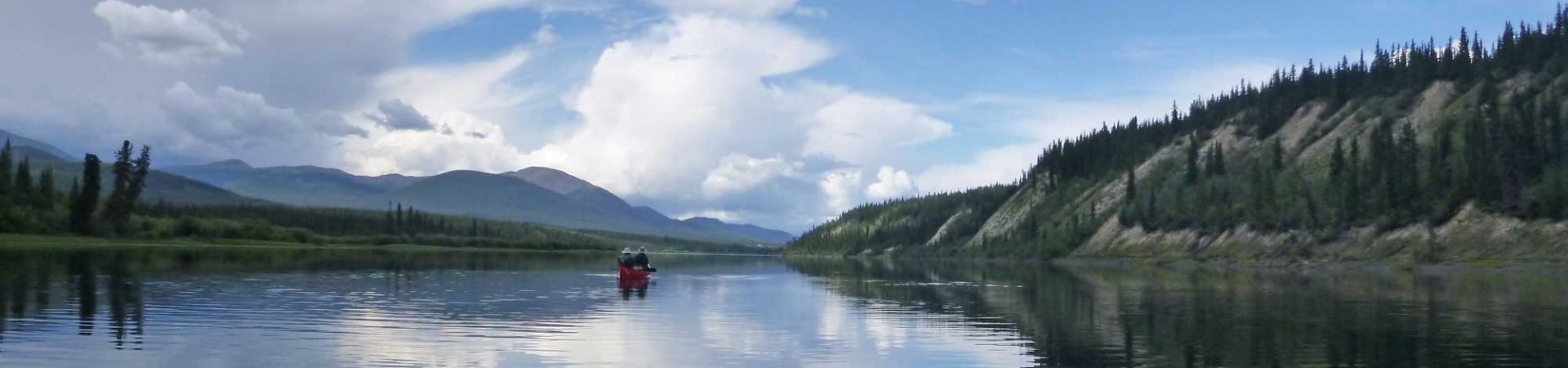
Launching our Old Town Guide canoe, we slid into the relatively warm waters, the only craft on the lake and spent a peaceful couple of hours circumnavigating the entire small lake. This being only our second voyage we improved our procedures for mounting and un-mounting the 74 lb canoe from the car, but only slightly. We greatly improved our load distribution by placing Cindy, the third person, more in the center of the canoe than previously, behind the carrying yoke, vastly improving the stability and fun factor of the canoe even when the wind kicked up. The views were beautiful from the water, opening up from the trees to low hills, grassy open space and finally at the far end of the lake, a bend of the shore hiding a lovely glassy part of the lake, rocky outcroppings jutting from the shore near a simple dam.

Dam at Meadow Lake
We beached the canoe on the far end of the dam, and were startled to step out on the beach teeming with movement, the source at first unidentifiable. Grasshoppers? Locusts? No, tiny frogs greeted us, hopping around like so much popcorn at the popping point. Frogs are so infrequently seen now, compared to when the three of us were young, that we were fascinated, peering down close to the ground to get a good look at the brown, hopping, bounding creatures, measuring only about three quarters of an inch long, their tiny legs winding up to propel them. We trod carefully on the small beach, taking care to avoid the blanket of frogs, and gazed down the water ravaged creek bed where spring runoff is diverted around the side of the dam, to course down the mountain at a high rate of speed to the valley far below. Walking around the back of the dam we could see the exposed granite boulders that were used in the original construction of the dam, later covered with concrete so it has the appearance of being a modern dam when viewed from the front. The dam, built in 1858, was built by settlers diverting water to gold mines located in the valley below the site. Summit City, a town site with 500 buildings and 2,000 residents existed on the other side of the dam in 1866, but was abandoned in 1872 when gold was found to be difficult to extract, and now only the dam remains.

Mike with “Baby Girl”
Returning to our launching spot we re-established the canoe on top of the car, our smoothest transfer yet, and took a short drive to the far end of the lake, noting the tangle of off-road trails that traverse the area. We hatched a plan to return next year to camp, canoe and bomb around in our friend, Mike’s, off-road Jeep, to which he willingly acquiesced when we proposed it later that evening at his home. His wife, Wendy, wasn’t quite as enthusiastic about the off-roading, but was intrigued about the lake and quieter pastimes of hiking, canoeing and a discovery expedition to locate remnants of the gold rush era town site. We were pleased to have discovered not only Meadow Lake, but the entire surrounding area, a veritable canoeing playland that we’ll continue exploring this fall and next summer.
INFORMATION:
My directions to Meadow Lake, from Truckee, CA, based on directions (see web link below) to Independence Lake:
Take Hwy 80 to 89 heading north. Travel a little more than 13 miles on 89 and turn west (left) at the Independence Lake sign (Forest Service (FS) Road 07 on map, not marked on highway). Stay on the main track. Keep going past the turnoff to Independence Lake (County Route 350) and continue on FS 07. Turn left at the sign to Meadow Lake ( FS 86), which is unpaved. 2WD ok, but the high clearance of an SUV is helpful. Keep following signs to Meadow Lake.
This site has a photo of the old town site:
http://www.ghosttowns.com/states/ca/meadowlake.html

Cindy & Steve
Jen says:
Hi! I loved your article about Meadow Lake. I just wanted to add that there is also privately owned land around the lake, including my families. We actually own the site where Summit City was located. We don’t own most of the shoreline though, except for a small area close to the dam, and for some reason we own only part of the cemetery. It is such a beautiful place that is very close to my heart. I am glad to see others enjoying it as much as I do. Thanks for sharing! 🙂
Gwen says:
Meadow lake was by far the most beautiful lake we saw while my family and I visited. We actually caught a few of the frogs and my kids decided to keep them as pets. We just don’t know what kind they are and what to feed them. We them store bought fruit flies but would like to know more.
Mark Geddings says:
My parents took us many times to Meadow Lake back in the 70s, used a VW bus and a pop up camper tent…we saw no other campers there when we were there every time. I read a lot while there. Lovely memories.
Inga Aksamit 2 says:
What great memories! What a fun place to go as a kid. Thanks for sharing.