


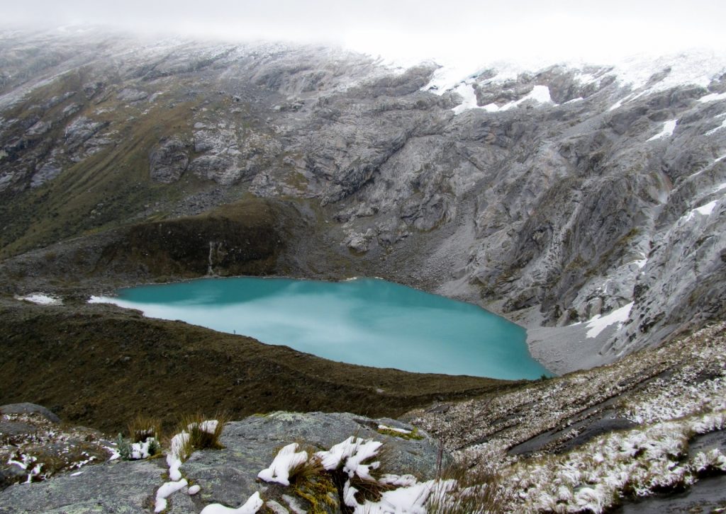
Lake Taullicocha, located below Punta Union, the highest point of the Santa Cruz Trail.
We were on our 3rd day of backpacking the Santa Cruz Trail in the Cordillera Blanca, a mountain range in Peru, and were ready to tackle the Punta Union, the highest point on the trail. My husband and I were hiking independently but had camped in a designated campsite near a guided group. For more information on planning a backpacking trip on the Santa Cruz Trail, see other articles listed at the end.
We were up relatively early but the tour group was ahead of us once again. They waved as they went past us with their little day packs on. It wasn’t as sunny as I had hoped, but it wasn’t raining, either, so that was a good sign. It was chilly though. I knew I would overheat but couldn’t bear the thought of stripping off layers so I started off with my down jacket under my raincoat and my merino wool neck gaiter and gloves. We strung up my ridiculous poncho to cover my pack and were off and running. Well, almost running. No, not really, we weren’t running at all. We were immediately gasping in the thin air.
I craned my neck to see where the group was. I really wanted to be near them when we went over the pass for some reason. The day was dark and ominous and I fretted over the unknown. I tried to hurry but that effort failed immediately due to hypoxia. I settled into a pace that would allow forward momentum while still providing enough air to keep me alive. I continued to be amazed at vegetation at this altitude. The grasses were still lush and green. Many small bushes dotted the sides of the canyon, which was narrowing into a rounded headwall that we had to ascend. Somewhere up there was the pass, now shrouded in thick clouds. The grey clouds blended with pure white snow blanketing the ridges above us, which contributed to my worry that we’d be inadequately prepared. I cursed myself for not bringing my Microspikes, a device with miniature crampons that slid over a boot to provide extra traction on slippery surfaces.
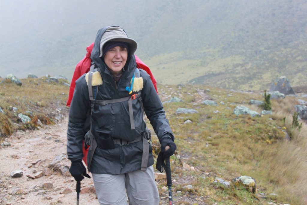
Inga is braving the elements as she nears the pass.
At first the walking was easy, though steeper than yesterday. We still had to ascend over 1,500 feet (457 m) though, so I knew that the incline would have to get a lot steeper before we topped out. The character of the grasses changed, becoming dryer and taller as the colors changed from green to tan. They reminded me of the bunch grasses we find in California. Still we saw yellow and pink wildflowers, some scrunched up tightly against the cold, waiting for a more welcoming day to show their full colors.
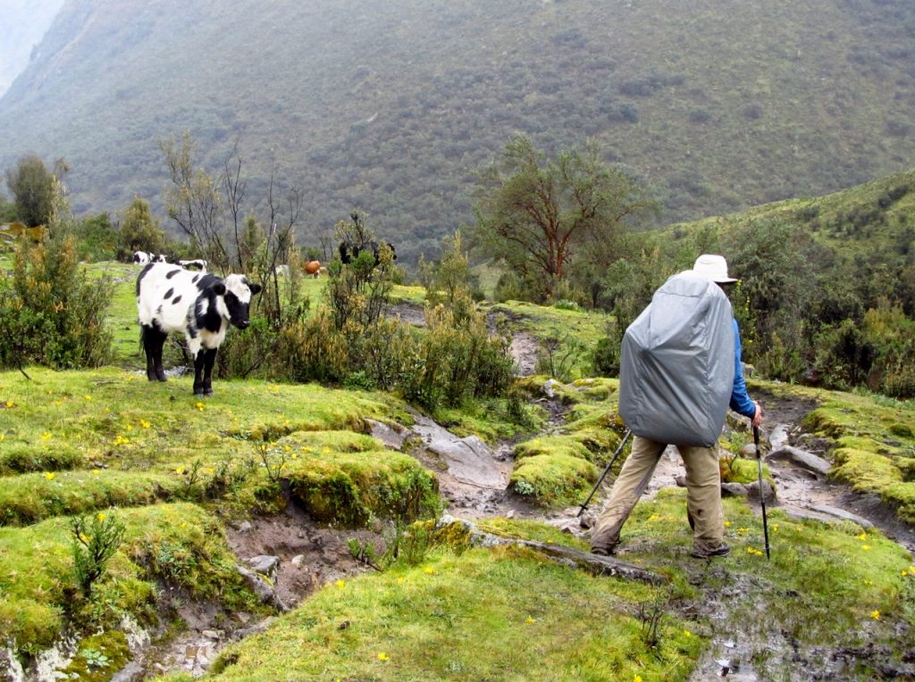
After about an hour the trail began angling up steeply through a series of long switchbacks that traversed the hillside. We tried to pick out where the pass was but the top of the ridge looked the same and there was no visible notch. A stream rushed by, which we crossed several times. I was still chilly and was surprised that even with the effort of going uphill I was still wearing all my warm layers. I had even added my brimmed hat and tugged the hood from my rain jacket to increase the warmth as the wind tore what little air there was from my mouth. The sky spat moisture from the sky, alternating between sleeting rain and hail and eventually snow. My steps slowed to a snail’s pace but I was able to maintain a slow, steady stride. Some pebbles clattered behind me and I turned to see the loaded mules and muleteers from the guided group drawing near. I let them pass, shivering as soon as I stopped. When I saw the muleteer strolling up the mountainside in his thick sandals, bare lower legs and just a poncho thrown over his shoulders I knew I was a big, spoiled baby.
The switchbacks made a big loop to the left under a long outcropping of rock and we were treated to amazing views of Lake Taullicocha far below, tucked into a narrow hanging valley below the snowy ridge we had been looking at all morning. The ridge formed the curving headwall that blocked our progress. The lake was the most amazing shade of turquoise, filled with glacial silt from the ages. The looping switchbacks kept going higher, giving us better and better views of the lake. Finally, the trail angled back to the right and we thought we spotted a potential notch that could represent the pass. Steve pulled ahead but my little steps were becoming shorter and shorter. The switchbacks continued and sometimes I caught sight of Steve up ahead. Eventually I looked up and could only see a few switchbacks. Steve leaned out to wave to me and shouted, “You’re almost there!” and I knew he was at the pass. I gazed up, almost succumbing to the thought that I could hurry it up, but it wasn’t happening. There was no lower gear to get into. “It’s only a few steps but it’s at least 20 minutes,” I shouted back over the wind. Steve laughed. “I know. Take your time,” he said.
![Inga at the pass, Punta Union [4750 meters (15,583 feet)]](https://ingasadventures.com/wp-content/uploads/2016/07/IMG_5192-1280x944-1024x755.jpg)
Inga at the pass, Punta Union [4750 meters (15,583 feet)]
The excitement and anticipation of reaching the summit, the mini-snowstorm and the stunning beauty of the hanging valley we were in kept things interesting but as we moved down the valley reality set in. We were tired, it was raining and we had a long way to go. Heads down, we just focused on making some miles until we could get to a campsite. The hiking was somewhat challenging as much of the path was comprised of rocks interspersed with mud and rivulets of water. If we chose our steps carefully we could hop from rock to rock and keep our boots out of the muck. It wasn’t hard as the rocks were plentiful but it took concentration. The scenery receded as we focused on connecting a very long series of dots to our destination.
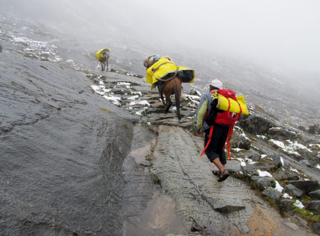
The familiar “uniform” of the local mueleteers: sandals, and short pants, no matter what the weather was like.
The familiar round roof of an outhouse came into view after several hours. “That wasn’t so bad.” I said. “Except that can’t be our campsite,” said Steve. “I believe we have much farther to go.“ A little while later we came to a fork in the road. One path led to the campsite but we took the other one. Miles later we came to another outhouse, this one occupied by a group of Spanish-speaking tourists with no packs. I figured we must be close to a town where people could come day hiking. It was pouring so we crowded in with them, smiled and laughed and could find no words to communicate. My Spanish had vanished so we stood around in the mild stench for a minute. Steve said, “I’d like to catch up to the other group and I don’t see their tents. I think we should keep going.” We knew this had to be a campsite or the structure wouldn’t have been there but we needed to make more miles if we were to get out at a reasonable hour the next day.
With that we transitioned to some of the most miserable hiking I’ve ever done. We were on a narrow muddy trail bordered by the river on one side and steep hillside on the other. At times the hill flattened out a bit but the forest was too thick to afford an alternate route. At other times the river angled away leaving pleasing-looking meadows between the path and the rushing water. That turned out to be a mirage, for the meadow was really an extension of a watery world where saturated mud held grass loosely in a bog too ephemeral to support the weight of a human. One such mirage beckoned us with such force that we succumbed. Steve strode into the morass to try to find a dry spot to pitch our tent, his shoes immediately disappearing into the muck. Ankle deep in mud he gestured for me to take an alternate route further to the right. Trying to hop from tussock to tussock my foot slipped and I was up to my calves in black muck that looked suspiciously like muddy cow/llama/mule dung. The mud sucked at my boots and suddenly I didn’t care what it was, I just wanted my boot to come out with my foot. We aborted our mission and continued our miserable slog. We were freed from our rock hopping efforts, however. With our lower legs caked in mud we just walked right through the middle of the soggy path, squishing mud between our toes as our hiking pants flapped around our ankles spraying mud everywhere.
Finally we reached the edge of a long meadow by the side of the river that was semisolid. Steve scouted around and found solid ground right beside the river under clump of trees. It was still raining and we were soaked and muddy so we strategized for a few minutes and planned where the tent would go, which end we would stake first and how we’d get in with the minimum amount of mud. Lickety split, the tent was up, gear was stashed in the gear closet and we strung up a clothesline to hang our wettest stuff. Not that there was any chance it would dry. It was just to keep it off the muddy ground and give us a place to store it in the rain. We repeated our procedure from the night before and dove into the tent, got in our sleeping bags to warm up and I took a short nap. When I awoke it was still raining but not as hard. That almost qualified as clear skies so I got up and puttered around, wringing rivulets of water from my socks, gloves and hiking pants. My boots were so incredibly disgusting that I actually took them down the river and submerged them entirely in the river using a rock to scrape most of the mud off. I knew they would never dry but I figured they couldn’t be much wetter than they were. I propped them up against a tree so water would drain out and hoped for the best. It had been a long day. However, it was our last full day on the trail and I knew a hot shower was waiting for me in Huaraz.
See related articles:
Hiking the Santa Cruz Trail in Peru: Day 1
Hiking the Santa Cruz Trail in Peru: Day 2
Hiking the Santa Cruz Trail in Peru: Day 3
Hiking the Santa Cruz Trail in Peru: Day 4
Planning an independent backpacking trip on the Santa Cruz Trail, Peru: Part 1
Planning an independent backpacking trip on the Santa Cruz Trail, Peru: Part 2
Day 3 stats:
Route: Taullipampa to Paria
Starting elevation: 13,943 feet (4250 meters)
Highest point: Punta Union Pass 15,584 feet (4,750 meters)
Ending elevation: Approximately 12,467 feet (3800 meters)
Mileage: 8 miles
Hiking time: 8 hours from camp to camp (including breaks)
Overall impression: A difficult day due to the high elevation of the pass, the extremely muddy lower descent and long hours of hiking.
Trip Stats:
Route: Cashapampa to Vaqueria
Starting elevation: Cashapampa 8,202 feet (2900 meters)
Highest point: Punta Union Pass 15,584 feet (4,750 meters)
Ending elevation: Ending elevation: Vaqueria 12,139 feet (3,700 meters)
Total mileage: 31 miles (50 km)
Itinerary: 4 days, 3 nights
Recommended guidebook:
The muddy trail.
Alison says:
Hi Inga,
My husband and I did a trek in the Cordillera Blanca in 2015, and it was challenging but beautiful. We were lucky to have pretty good weather (sunny but very cold!) the whole time, so I can only imagine what the discomfort at Punta Union must have been like in your tough conditions. Kudos on tacking a tough trek on your own!
I enjoy reading your blog and devoured your book before heading out on the JMT last summer with my husband. I also belong to many of the same JMT Facebook groups that you do. I seem to recall you mentioning that you did the TMB recently in one of those discussions, but I do not find any information about your experience on your blog. My husband and I are thinking about hiking the TMB in 2017 and were curious about what you thought of the experience. We love hiking and photographing beautiful mountain scenery and are wondering how the TMB stacks up against the JMT in your opinion. Any advice/recommendations/hesitations would be greatly appreciated.
Thank you!
Alison
Alison says:
Thanks for the informative reply, Inga. I just checked out your TMB overview article on Niume. com. Thanks for pointing me to it. Cheers!