The John Muir Trail, which traces an undulating 211-mile path up and down the High Sierra while crossing numerous 10,000-14,000 foot passes, requires some logistical planning. The trip itself can be completed in roughly two to four weeks (or as little as a few days for elite athletes like Ralph Burgess) or much longer, depending on age, fitness and personal hiking philosophy (hikers who “make their miles” vs those “stop and smell the roses”). My husband, Steve, and I hiked 23 days on the JMT. After following the John Muir Trail discussion forums for a couple of years and hiking the trail, I have compiled a list of the top 10 apps, maps, gadgets and gear to consider for hiking the iconic trail. Exactly what to take is a personal decision. Some prefer to navigate with a minimum of gadgets while others choose to introduce technology into their backpacking checklist. I take a middle of the road approach. I carry a paper map and compass but appreciate the convenience that a quick GPS check offers. Map apps have a lot more detail than some maps, including water sources and camp sites. I use my phone to read and listen to podcasts, but I don’t want to be so connected that I’m sucked into talking, texting and checking Facebook.
If your budget can handle it, consider getting a variety of JMT maps and guides. Some will be better to refer to during planning, while one or two will be your primary resource on the trail. We used the Tom Harrison maps when researching the trail before and answering questions after hiking the trail but thoroughly enjoyed reading every word of Elizabeth Wenk’s guidebook in digital form while on the trek. The Erik the Black Atlas was our primary navigation tool while hiking, but we appreciated being able to double-check against Guthook’s app. I often use the Tom Harrison maps when I’m researching trail locations.
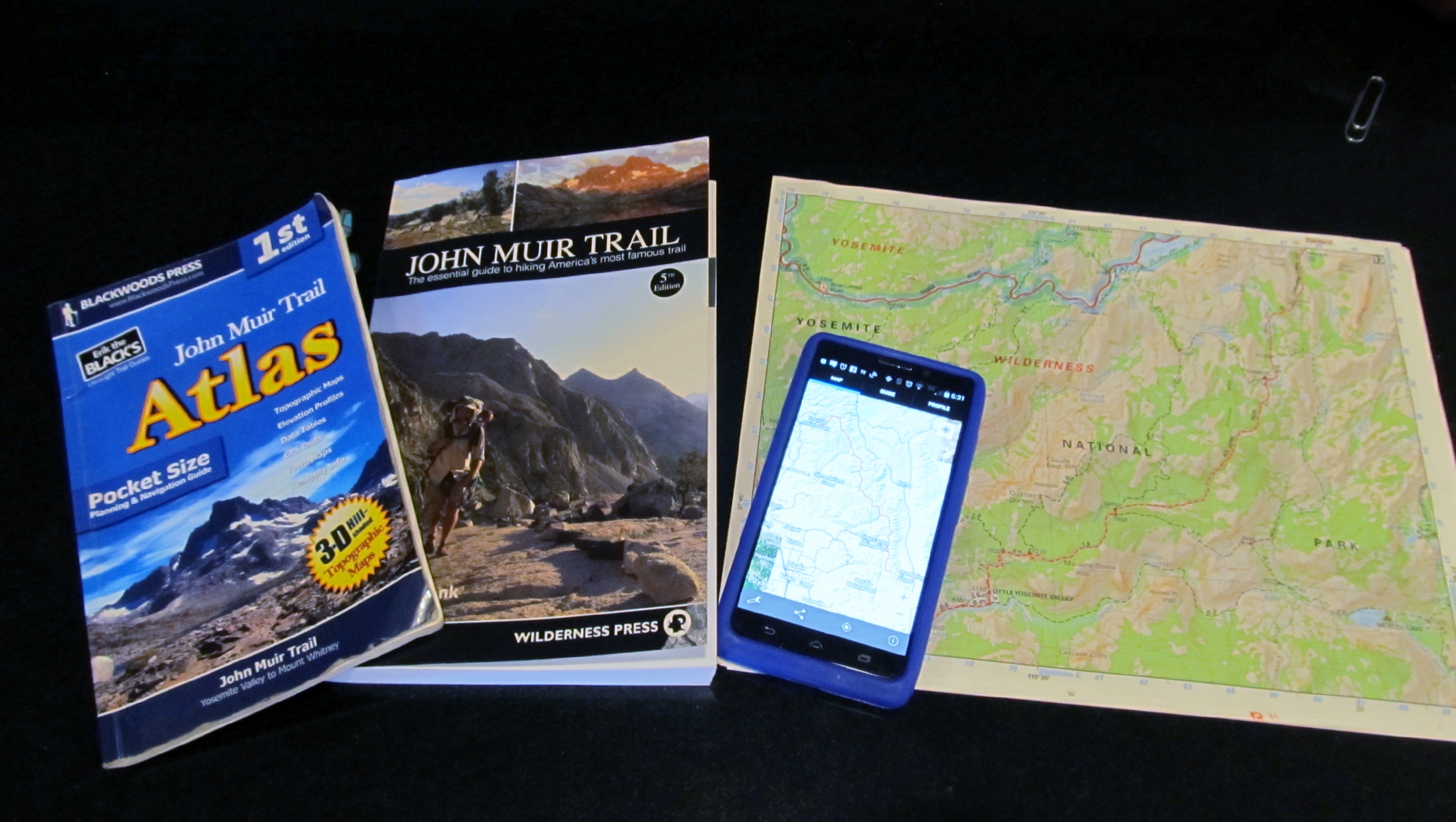
- John Muir Trail: The Essential Guide to Hiking America’s Most Famous Trail by Elizabeth Wenk ($16). This guidebook is what the name implies, an essential tool in the toolbox. Chances are, most people you see on the trail will have this book in paper or digital form. It is the definitive guidebook for the trail and contains complete descriptions of the trail, as well as the flora, fauna and geology that you’ll see on the trail and the history of what preceded you. There is a comprehensive section on planning, history of the trail and Sierra and 13 chapters on individual sections of the trail. She lists GPS coordinates and maps for prominent campsites, trail junctions, bear boxes, and other points of interest. I had a hard time digesting so much information before the hike, but it was a highlight of every evening to read about the next day’s section coming up. I also found answers to almost all of my questions about the natural environment and history, which only occurred to me while hiking the trail. A valuable adjunct is Wenk’s Data Book, or the data sheet, a 2-page front and back list of every campsite and water source on the trail. The data sheet is available for free download in the files of the Yahoo group (see # 9 below). If you’re a wildflower enthusiast you might also be interested in Wenk’s Wildflowers of the John Muir Trail and High Sierra, available in print or digital form (but again, the digital version weighs nothing).
- John Muir Trail Pocket Atlas by Erik the Black, Blackwoods Press ($29.95). The invaluable and compact Atlas fits easily into a backpack pocket, but the 5 x8 inch booklet is a bit too large for a shirt pocket. This may be all you need for the trail, with detailed topo maps, tent site and water locations, and landmarks, all clearly identified in 43 sections of the trail. At the top of each section, a grid shows mileages between landmarks and the elevation profile. Town maps are given for four potential resupply or exit towns and information about backcountry resupply stations and public transportation are listed at the front. Our Atlas was dog-eared from use as it was our #1 source during the hike. I also ordered a JMT wall map ($14.95), which was helpful to get an overview and to leave at home with family. I was touched that my parents had pinned the map on the wall of their bedroom to track my daily SPOT Messenger location messages. Erik’s website is packed with helpful ultralight backpacking tips.
- John Muir Trail Map-Pack by Tom Harrison Maps ($17-21). Harrison says he has the best full-color, shaded relief, waterproof paper maps and he is right. His maps have color-coded symbols and trails, mileages between trail junctions, latitude/longitude, UTM grids, contour lines, vegetation, and elevations at trail junctions. The JMT Map Pack is a set of 13 8.5×11 inch maps that the trace the JMT. Most people choose either this set or Erik the Black’s Atlas. The number of pages to keep track of deterred us from using them on the trail but we used them while planning. I’ve written about various aspects of the trail and answered innumerable questions on forums and have found myself referring to them a lot. Regular Tom Harrison maps are also available for many other areas of the Sierra—these are large folding maps which are different from the JMT map set.
- Far Out JMT Guide app by Atlas Guides ($15). This Android and Apple app, previously known as Guthook, is a thoroughly researched and reliable application that uses the GPS locator on a phone to pinpoint an exact location. I can get a GPS signal on my Android phone in remote locations where cell service will never reach. Different icons demonstrate where water sources, tent sites and trail markers are. The elevation profile shows current location and upcoming terrain. Click on an icon and it gives a complete description of the location, the next reliable water source and displays one or more photographs. A couple of times the app showed campsites that weren’t listed on any of our other resources which were helpful when we needed a place to camp. We were very impressed with all the information presented in the app though we didn’t use it that often. Guthook also has apps for other trails such as the PCT, Mt. Whitney, Tahoe Rim Trail and many others.
- HalfMile Trail Notes. The HalfMile app and maps no longer exist, unfortunately, but the Trail Notes are still a valuable source of information for the Pacific Crest Trail.
- GaiaGPS is a mapping app with free features and a premium subscription that opens up additional features. Some of the extra features with the premium subscription are quite valuable, including snow coverage, avalanche risk and fire and smoke map layers. You can plot your own route on your desktop and it syncs to the app on your phone.
- CalTopo is a free mapping tool that can be used to plot your own topo maps. There is now a CalTopo app and routes can be exported to other GPS apps. Maps can be downloaded and printed. There is a learning curve that isn’t too difficult to master if you are somewhat technically inclined. CalTopo is useful for planning side trips around the JMT where routes fall off of the defined JMT trail maps.
- GPS Status & Toolbox app by MobiWIA-EclipSim (free). This simple and straightforward Android and Apple GPS app strips away the clutter to present GPS locations in a variety of formats the user can choose from, along altitude readings and compass heading. I like to use this app to verify my location on a paper map and get a quick read on the altitude.
- John Muir Trail Facebook Group. Several Facebook groups are available to answer any and all questions, such as John Muir Trail (>40,00 members), Ladies of the JMT (>12,000 female members), Altitude Acclimatization and more. Search the groups for commonly asked questions and be prepared for a lot of input when asking questions.
- John Muir Trail on Groups.IO. This group, which evolved from a Yahoo group established in 1999, is informative, supportive and well-moderated, offering a discussion forum for absolutely any question you might have about hiking the John Muir Trail, from what food to take to locations of cell signals. Their extensive and up to date set of files contains valuable information about a variety of trip planning subjects, including a variety of spreadsheets to satisfy the geekiest engineer.
Since the time I originally published this article (which has been updated regularly), more resources have been published. The products on this list remain my favorite resources. I prefer to support these authors and cartographers who walk the trails themselves taking thousands of data points along the way to make their guides the most accurate they can be.
The average hiker doesn’t need all of these items to have a successful JMT hike, but some combination of these navigation tools, guides and devices will aid in planning and finding your way.


Lisa says:
The Guthook apps are the best! I’ve used the AT Hiker (for a 2015 thru) and PCT Hiker apps (for 2015 segment hikes) and am now using the JMT Hiker app to help plan my upcoming JMT hike this year (in conjunction with the PCT app for the sections not part of the JMT since I’m entering at Cottonwood Pass (south of the JMT).